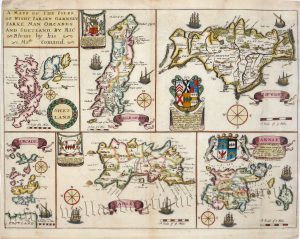

A decorative and detailed mid 19th century map of the Channel Islands (Guernsey & Jersey) which was drawn and engraved by J. Rapkin (illustrations by E. Radclyffe) and published in John Tallis & co.’s The Illustrated Atlas (London & New York: c.1851). The original page of text which accompanies the map is included.
The Illustrated Atlas, published from 1849 to 1853, was the last decorative world atlas. The Channel Islands map was typical of the many fine ones that appeared in this work with its ornamental border and attractive vignettes. Illustrated are scenes of St. Peter’s Port, Castle Cornet, a Druidical Altar near Lancresse, Mont Orgueil Castle and Jersey itself.
- This is an original steel engraving with original hand colour.
- Printed area is approximately 25.1cms by 35.3cms.
- The map is in very good condition with decent margins. Click on image for a better view.
- Click on ‘Delivery Policy’ for postage costs.
- Guaranteed to be over 155 years old.